


Noyant la gravoyère

bubuserge
User
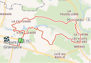

Length
13.1 km

Max alt
98 m

Uphill gradient
230 m
Km-Effort
16.2 km

Min alt
32 m

Downhill gradient
232 m
Boucle
No
Creation date :
2022-05-05 07:02:54.0
Updated on :
2022-05-05 10:19:55.759
2h51
Difficulty : Difficult

FREE GPS app for hiking
 SityTrail
IGN / Geographical institutes
SityTrail Plus
The world is yours!
About
Trail Walking of 13.1 km to be discovered at Pays de la Loire, Maine-et-Loire, Segré-en-Anjou Bleu. This trail is proposed by bubuserge.
Positioning
Country:
France
Region :
Pays de la Loire
Department/Province :
Maine-et-Loire
Municipality :
Segré-en-Anjou Bleu
Location:
Noyant-la-Gravoyère
Start:(Dec)
Start:(UTM)
653327 ; 5285475 (30T) N.
Comments